
Civil Site Work or Commercial Construction for Beaumont Projects?
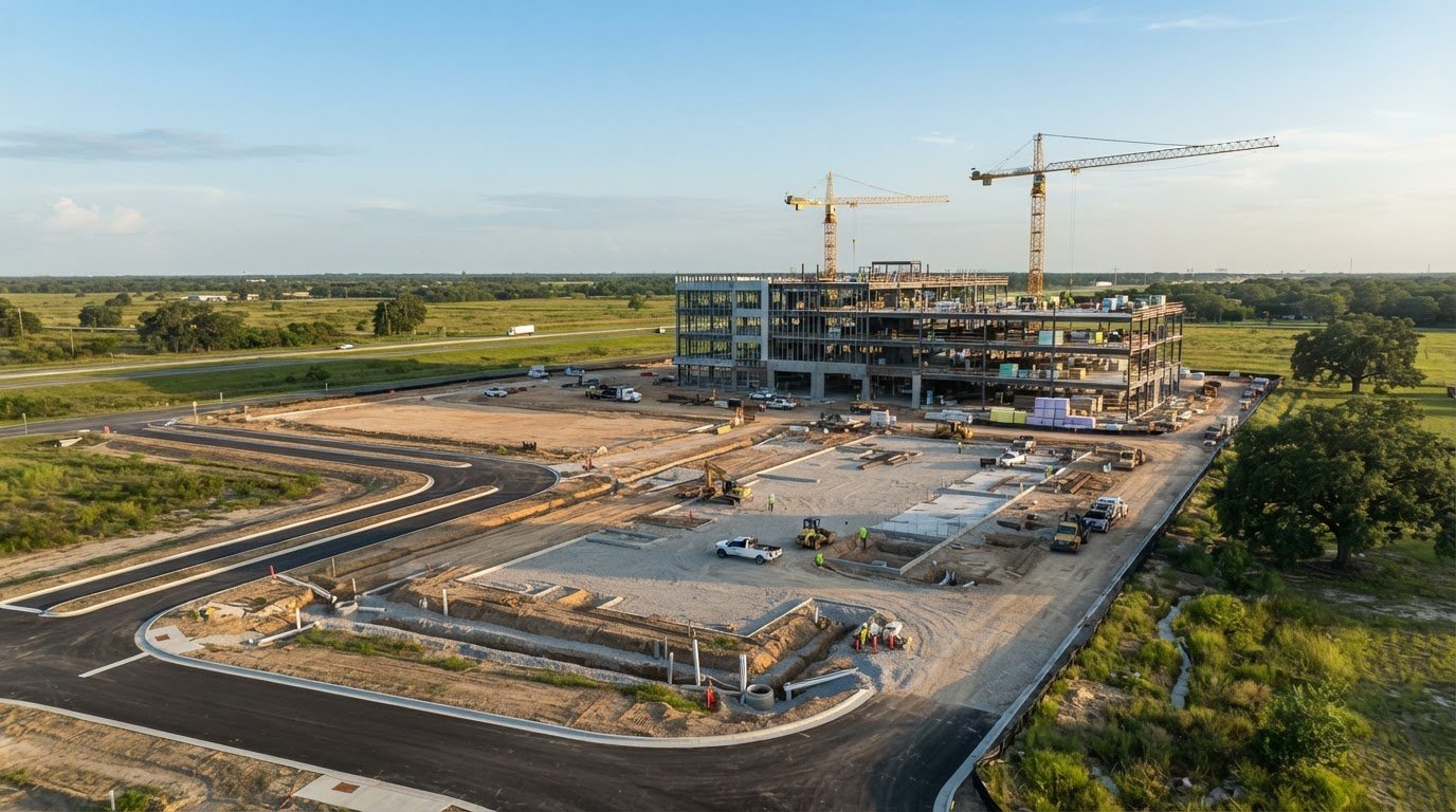
The building is only one part of a commercial development. Civil site work for commercial development in Beaumont prepares and services the land, including grading, utility connections, and site access. Commercial construction focuses on the building itself. The scopes often overlap where site preparation, accessible routes, utilities, and permitting connect the property to the finished structure.
It’s easy to focus on the building, but the site and grading plans shape how the whole project functions. In Beaumont, many new development projects are required to include public street improvements, so site work can extend beyond the property line.
This guide explains what civil construction covers, how it differs from commercial construction, and where the two scopes meet. It also explains how grading plans coordinate site elevations, drainage, and access so development decisions can be made in the right sequence.
Key Takeaways
- Separate site preparation and infrastructure from building construction, then identify where the scopes need to coordinate.
- Map utility connections early so water, wastewater, storm drainage, and dry utilities can be planned alongside the development.
- Account for off-site infrastructure and agency coordination when shaping commercial or retail land plans.
- Use grading plans to align site elevations, drainage, and access with the project’s broader layout.
- Include public street improvements where required and coordinate site plans with Beaumont’s applicable review and permitting requirements.
Projects requiring both civil and commercial construction
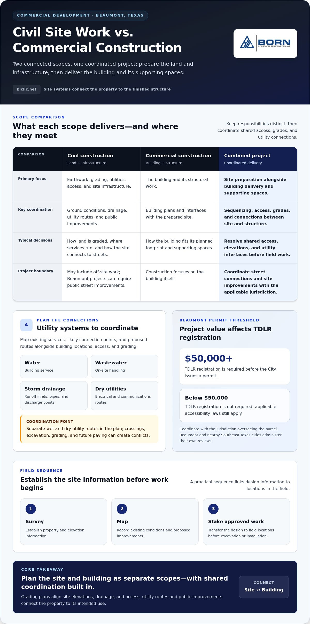
Commercial projects combine site preparation with construction of the building and its supporting spaces. In Beaumont, Texas, these scopes meet where grading, access, utilities, and public improvements connect the property to its intended use.
Beaumont and Nearby City Requirements
Beaumont’s site work follows the requirements of its own jurisdiction, while nearby Southeast Texas cities administer their own reviews. The available project facts don’t support a detailed city-by-city comparison, so plan for local review of street connections, utilities, and site improvements rather than assuming neighboring jurisdictions share identical processes.
For a project near a city boundary, first establish which jurisdiction oversees the parcel. Then coordinate the site layout and proposed infrastructure with its review process. This distinguishes work in Beaumont from development governed by another Southeast Texas municipality.
Permits, Costs, and Project Timelines
In Beaumont, commercial projects valued at $50,000 or more require TDLR registration before the City issues a permit. Projects valued below $50,000 don’t require TDLR registration, though applicable accessibility laws still apply. Cost per acre depends on grading quantities, soil conditions, utility scope, access, and required improvements. Schedule depends on work sequencing and coordination; no single duration applies to every site.
Plan temporary staging and earthwork balancing together. Set aside workable areas for equipment, material handling, and soil movement while keeping construction access routes open. A balanced earthwork plan considers where excavated material can be reused and how its movement relates to the building footprint and site improvements.
Surveying establishes property and elevation information. Mapping records existing conditions and proposed improvements, while construction staking transfers the design to field locations. A practical sequence is to survey first, map existing conditions and the planned layout, then stake the approved work before excavation or installation begins.
| Project scope | Typical focus | Coordination priority |
|---|---|---|
| Civil construction | Earthwork, utilities, access, and site infrastructure | Ground conditions and public improvements |
| Commercial construction | Building and structural work | Building plans and site interfaces |
| Combined project | Site preparation and building delivery | Sequencing, access, and connections |
Choose a coordinated scope when site preparation and building work depend on shared access, grades, or utility connections.
Beaumont’s construction directory lists 8 companies with 1-10 employees, 14 with 11-50, 5 with 51-200, 2 with 201-500, and 1 with 501-1,000. These ranges describe directory company sizes, not project capacity. Sustainable construction planning can include separating reusable materials from other construction waste and identifying suitable recycling streams. For examples of completed work, review construction project examples as you consider how site and building scopes fit together.
What Is Civil Construction?
Civil construction establishes the site systems that support a building and its daily use. In Beaumont, utility planning connects land development with the infrastructure serving the property.
Utility Coordination and Conceptual Plans
A conceptual utility plan maps proposed connections before detailed installation drawings are prepared. The team identifies existing services, likely connection points, and routes across the site, then coordinates them with building locations, access, and grading. Unlike utility installation, planning establishes how systems fit together and where design conflicts may need resolution before field work begins.
Storm Drain and Dry Utilities
Storm drains manage runoff through inlets, conveyance pipes, and planned discharge points. Dry utilities, such as electrical and communications lines, need separate routes coordinated with wet systems. Because routes can cross, a shared plan helps identify conflicts and reserve space. On an industrial development in Beaumont, on-site water, wastewater, storm drain, and dry utility improvements support the project.
Utility Connections and Site Risks
Utility connections link on-site systems to available service infrastructure. Environmental, drainage, and construction risks can include disturbed soil and sediment moving with runoff, drainage routes conflicting with site work, and utility alignments crossing excavation areas. These risks depend on existing conditions and design choices, so teams coordinate proposed routes with grading and construction sequencing.
Coordination begins with information about existing conditions. Survey and utility records help designers compare known lines with proposed building footprints, streets, parking areas, and service corridors. The team can then identify likely connection locations and reserve workable routes before finalizing the site layout. Field verification and design coordination refine routes as plans progress.
Water and wastewater planning addresses building service and how wastewater is handled on site. Storm drainage has a different purpose: directing runoff through a planned system. Electrical and communications routes must also reach the development without obstructing access or conflicting with other utilities. Keeping these systems distinct in the plan makes their interfaces easier to review.
Construction sequencing matters. Utility corridors need to be coordinated with excavation, subgrade preparation, and eventual paving. If a connection crosses a future street or building area, the project team can account for it before surfaces or structures restrict access. This planning helps prevent avoidable clashes between separate work packages.
For a commercial project, the useful next step is to align the conceptual utility plan with the site layout and grading approach. Commercial construction project examples can help illustrate how site systems and building work relate across completed developments.
Commercial and retail land development
Commercial and retail projects both need land planning before construction begins. Their site layouts differ according to intended use, access needs, and infrastructure connections.
Commercial Land Development
Commercial land development prepares a property for business uses such as offices, warehouses, or industrial facilities. Planning connects building placement with site access, utilities, grading, and required public improvements. For a Beaumont project, review property boundaries and existing conditions, then coordinate preliminary plans with relevant city, county, and state agencies. Early coordination helps identify infrastructure needs before detailed design.
Industrial development can involve substantial site infrastructure beyond the building footprint. Beaumont project planning should account for utility corridors, internal circulation, loading areas, and off-site work connected to the proposed use. Public street improvements may be required during development plan preparation. Identify these potential interfaces early because they can affect site access, construction sequencing, and the relationship between private land and public right-of-way.
Retail Land Development
Retail land development serves customer-facing uses, so the layout must make entrances, circulation, and connections to surrounding streets clear. Unlike an industrial site, which prioritizes operational movement and service access, retail planning also needs to organize visitor arrival and movement between destinations. A site plan can test building orientation, pedestrian routes, parking placement, and delivery access before construction documents establish precise details.
For a retail parcel in Beaumont, assess how proposed access connects with adjacent streets and nearby properties. Coordinate those routes with grading and utility layouts so drive aisles and pedestrian paths work with site infrastructure. Public street improvements can shape the frontage plan, so consider them alongside on-site access rather than as an afterthought.
Commercial Site Plan and Engineering Requirements
A commercial site plan brings together property layout, building locations, access, grading, utilities, and proposed improvements. Civil engineering translates that arrangement into coordinated site systems. In Beaumont, many new development projects are required to provide public street improvements as part of plan development. Site planning differs from building design: the latter focuses on the structure, while the civil plan addresses how the full property functions.
A practical review can proceed in sequence. First, map property boundaries and existing conditions. Next, place proposed buildings and access points, then coordinate grading, drainage, and utility corridors. Finally, identify street connections and public improvements related to the development. Each step informs the next: changing a building location can alter access routes, service connections, and grading relationships.
For commercial or retail land, the intended use determines which site relationships need the closest attention. An industrial layout emphasizes operational access and service areas; a retail layout prioritizes clear customer circulation alongside deliveries. In either case, Beaumont planning should coordinate private site design and required public improvements before construction begins.
Grading analysis and conceptual grading plans
For a Beaumont building site, grading coordinates proposed elevations, earthwork, drainage, and infrastructure. Analysis tests how these elements fit the site before detailed plans guide construction.
Grading Analysis
Grading analysis evaluates existing ground and proposed elevations across a building site. It helps the design team determine where earth must be cut, placed, or balanced, and how the finished surface relates to buildings, access, and drainage. For example, a loading area and nearby building entrance may need different elevations while remaining connected by usable routes.
Start by comparing surveyed ground conditions with the building footprint, vehicle paths, and drainage direction. Then assess how proposed grades meet property edges and planned infrastructure. Grading analysis evaluates constraints and relationships; a grading plan records the selected design for coordination and construction.
On a commercial parcel, changing one finished elevation can affect nearby paving, entrances, or utility alignments. Reviewing these interfaces together helps identify conflicts while the layout is still being developed.
Conceptual Grading Plans
A conceptual grading plan shows the intended landform before detailed construction documents are prepared. It identifies preliminary building-pad elevations, general slope directions, and transitions between developed areas. Grading analysis evaluates conditions and alternatives, while the conceptual plan communicates a preferred approach for coordination with the site layout.
Use the plan to compare how building pads relate to access drives, parking areas, and drainage routes. For example, a retail entrance, service area, and adjoining drive aisle need compatible elevations and practical transitions. The concept also gives the project team a shared reference for reviewing building placement and civil infrastructure.
As design advances, update the concept when building locations, access points, or drainage paths change. Keeping these elements aligned helps prevent revisions in one discipline from creating conflicts elsewhere on the site.
Soil, Geotechnical, and Floodplain Considerations
For a Beaumont building site, assess soil bearing and variability through geotechnical evaluation, then relate the findings to earthwork and foundation design. Review floodplain mapping and drainage paths alongside proposed finished elevations, since each can influence grading choices and infrastructure placement.
Soil conditions matter because they affect how the site can be prepared and support planned improvements. Geotechnical findings inform decisions about subgrade preparation and whether proposed grades suit the observed ground. The grading concept should reflect these findings rather than treat the site as uniform.
Floodplain review and drainage analysis address related but distinct questions. Floodplain information shows how the site relates to mapped areas, while grading analysis considers how runoff moves across the proposed layout. For a Beaumont project, coordinate these reviews with building pads, access routes, and drainage infrastructure before advancing the grading design.
Bring the survey, geotechnical findings, floodplain review, and site layout together during concept development. This gives the design team a clear basis for refining elevations and coordinating grading with the rest of the project.
What are Beaumont's commercial site plan and civil engineering requirements?
Beaumont commercial plans must coordinate site layout, civil engineering, building design, and applicable code requirements. A coordinated submittal connects property improvements with streets, utilities, grading, and the proposed structure.
The City of Beaumont has adopted the International Building Code, International Fire Code, and International Plumbing Code. It has also adopted the National Electric Code and requires proof that new construction complies with the International Energy Conservation Code. These requirements cover different parts of a project, so the plan team should coordinate civil and building documents rather than treating them as separate designs.
For site planning, assemble the major components in a consistent drawing set. The site layout should show proposed buildings, access, parking, property boundaries, and improvements. Civil engineering plans should coordinate grading, drainage, and utility routes with those locations. Building plans then need to align with the site information, including entrances, service areas, and connections.
Street interfaces require particular attention. Beaumont requires many new development projects to provide public street improvements as part of plan development. Identify where proposed access meets the public street, then coordinate the connection with internal circulation and grading. This helps the project team address the relationship between the property and public infrastructure before construction begins.
Code coordination involves more than the structure itself. The adopted fire and plumbing codes affect building systems, while electrical and energy requirements apply to their respective design elements. Keep the civil plan aligned with building documents, especially where utility connections, building access, or site elevations meet the structure. A change to one element can require updates across multiple drawings.
Permit approval and occupancy are separate stages. Beaumont requires TDLR registration before issuing a permit for commercial projects valued at $50,000 or more. Projects below that value don’t require TDLR registration, but applicable accessibility laws still apply. A tenant or owner cannot begin moving in until all final inspections pass. Plan for those inspections as part of project closeout, not as a substitute for earlier coordination.
A practical review sequence is to confirm the site layout, coordinate civil and building plans, identify public street improvements, and align the drawings with applicable codes. Then track revisions across disciplines so updated access, grading, or utility information appears consistently in project documents. This keeps coordination focused on how the site components function together.
For a useful reference point, review commercial construction project examples and consider how site improvements relate to building work in a coordinated development.
Born Integrated Construction: Concrete Paving
Born Integrated Construction provides Concrete Paving for commercial projects where site access and durable paved surfaces are part of the development scope. Turn to the team when plans call for paving coordinated with the wider project. Related services include Slab on Grade, Podium Slabs, and CIP Garages, connecting site and structural concrete needs within commercial construction.
Clear project plans help align paving work with grading, access, and adjacent construction. For a broader view of completed work, explore Born Integrated Construction project examples.
Visit Born Integrated Construction online to discuss Concrete Paving for your project.
Move Your Beaumont Project Toward Construction
The next step for civil site work for commercial development in Beaumont is to align the site plan with the construction scope. Clear coordination around access, grading, and building interfaces gives the project team a practical basis for advancing design and sequencing work.
Before that discussion, bring the current site layout and identify where concrete work connects with the broader development. A focused conversation can help establish how the required scope fits the project’s priorities and construction plans. Born Integrated Construction provides Concrete Paving, Slab on Grade, and Podium Slabs.
Contact Born Integrated Construction to discuss your Beaumont project and its concrete construction needs. A considered next step can help carry the plan forward with clarity and purpose.
Frequently Asked Questions
What is being built in Beaumont, Texas?
Beaumont’s project activity includes transportation, parking, and public-facility work. Examples include Highland Avenue roadway rehabilitation, the City of Beaumont Landfill RNG Facility, and Education First FCU’s new parking project. That parking project covers 11,000 square feet. These examples show that local construction extends beyond commercial buildings to include public infrastructure and site improvements serving institutions and businesses.
What kind of construction is happening in Beaumont?
Beaumont has both new construction and renovation or remodel projects on file. The records include 460 new-construction projects and 1,023 renovation or remodel projects, illustrating activity across new development and existing properties. For a commercial owner, that distinction matters: a vacant parcel may need coordinated site development, while an existing property may require work that fits around its current buildings and access.
What civil site work is required for commercial development in Beaumont, Texas?
Commercial civil work generally prepares the property and connects it to surrounding infrastructure. Its scope depends on the parcel, proposed use, and public interfaces. Define the work limits first, including property boundaries, access tie-ins, and utility connection points. Then coordinate those interfaces with the building schedule and construction staging plan. This helps distinguish on-site work from improvements affecting streets or adjoining infrastructure.
What are Beaumont's stormwater drainage and detention requirements for commercial sites?
Stormwater planning for a Beaumont commercial site should show how runoff moves across the developed property and where it is managed. The design considers roofs, paved areas, grading, drainage routes, and the proposed discharge point. Detention may be part of the site solution when the project design calls for it. Coordinate drainage features with building placement and access so they work as part of one site layout.
What are the water, sewer, and utility connection requirements for Beaumont commercial developments?
Commercial plans need to coordinate water, wastewater, storm drain, and dry utility connections with the buildings they serve. Identify proposed connection points and reserve routes through the site before finalizing building placement, drive aisles, and other improvements. For an industrial development, on-site water, wastewater, storm drain, and dry utility improvements support the project. Coordinate utility routes where they cross paved or building areas.